
Very Active Pattern Suddenly
Colder, Stormier USA With Frequent Rain Events South, Fast-Building SnowPack MidWest to Northeast

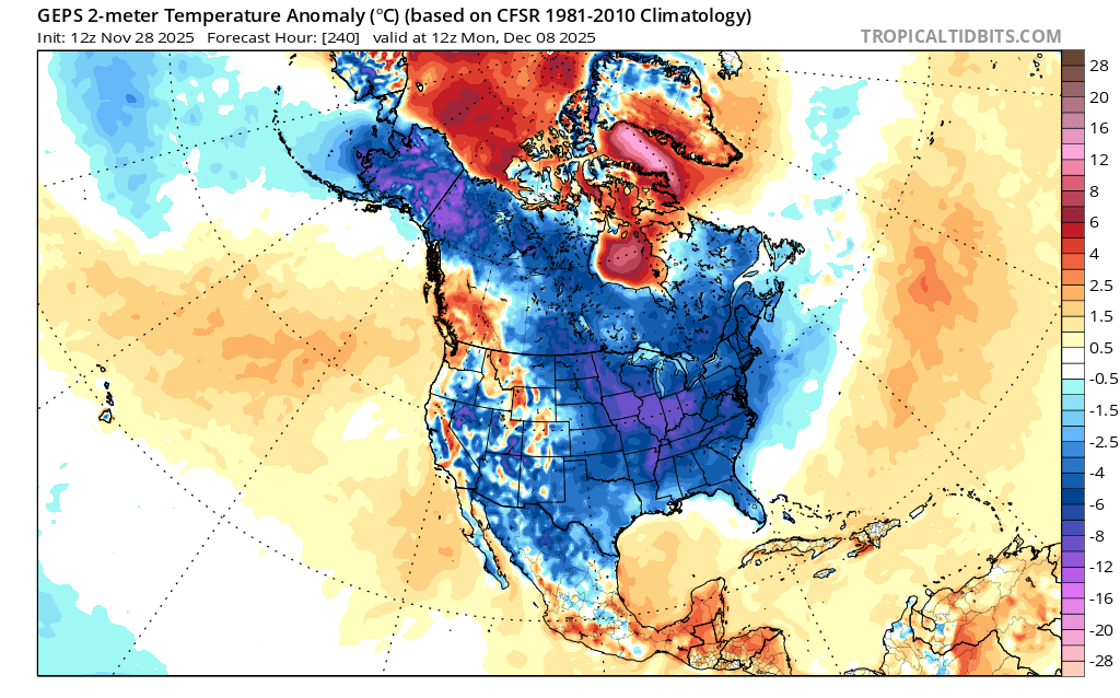
The pattern has flipped, about as expected. This may be due to the sudden warming near the upper troposphere near the Arctic, which is ongoing now, and helping to disturb and weaken the Polar Vortex. But in my opinion, it’s probably more related to the ebb and flow of our pattern going back to last Spring, where we went stretches even then, with Negative NAO, and warm, then cold, wet, then dry—all for long stretches at a time. In my part of North Carolina, it has been extremely weird in the rain department all year, sometimes very wet for 2 week stretches, then very dry for several weeks (practically no rain weeks on end). Also, even though temps were warm this Fall, things have flipped similarly to the last 2 seasons, in late November, very near ThanksGiving—to colder. And I expect, with the Negative NAO and a weak blocking signal there in Greenland to the Pole, to north of Alaska, all of that will keep on keeping on with the bigger picture of how things transpired last Winter, also a La Nina. This time though, we are MUCH, MUCH more active with precip events showing up and right now, I do believe those will benefit the Southeast all of December and since this is a weak Nina, slightly different than last year, the upcoming Winter as a whole will be remarkably wetter than last Winter. If you recall, last Winter ran colder but drier overall (that cold led to major Gulf Snow though and suppressed events). This season looks like not nearly as dry to me, but perhaps harder to forecast will be the temps when all is said and done for the entire Winter. Most likely, we will keep on flipping wildly on temps….sometimes very cold, sometimes abut normal cold, and at times, very warm with southwest flow. But through the next few weeks I would not count on much of that latter showing up (the warm, southwest winds). That may happen latter December, roughly Christmas time give or take a few days though, based on ebb and flow of rough pattern swing estimations. It would be extremely unusual to have non-stop Eastern USA trough all of the entire month of December—so I doubt that happens this time.
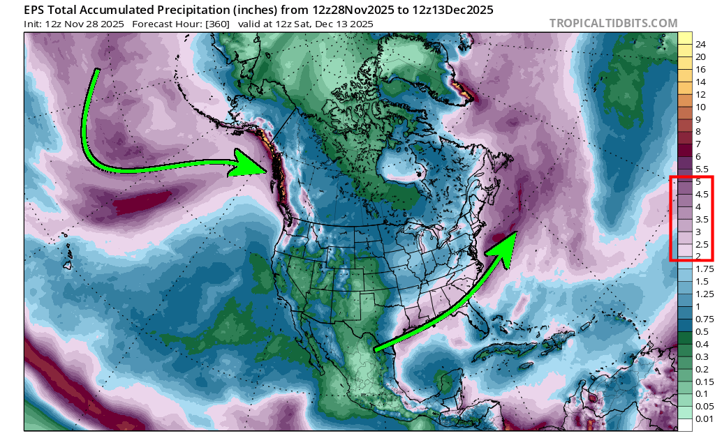
However, all this said—things are getting very active next few weeks for a bunch of reasons, and every model has some signs of western Canada or eastern Pacific Ridging, which favors downstream troughing in the eastern half of the nation. Thats a pretty cold pattern—atleast average cold, and tending to much more cold our immediate north. And with models showing a very active Pacific jet constantly bringing systems into either Southern Alaska, or western Canada and then quickly diving toward the Southwest or Rockies, these systems keep right on pressing east bound. Until now, they have usually decayed and not dropped much precip in the Southeast (especially east of the Apps). But now, they are further south, tapping the Gulf, more often and holding together better, so we have Gulf Lows showing up. In fact, there are several southern systems shown to potentially run through the Southeast through mid December. Each one will be possibly having big snow on their north sides, just like what recently happened, and what is going to happen this weekend in the MidWest and Lakes, and then what is going to happen in part of western Kentucky to Ohio Valley to Pennyslvania to the Interior Northeast this early next week. This is one very busy pattern, laying down a lot of snow all of a sudden in the eastern Plains, the MidWest, the Lakes and the Northeast. Out of nowhere, within 10 days, a vast snow pack has been laid (or is in the process as we speak). Wild Stuff.
The European even though it has struggled with too much western trough shown out in the distance, it usually corrects itself within a few days. And lately it’s much colder than the GFS in the extended. Lately its ensembles are more Wintery looking for the eastern half of the nation with some weak Greenland ridging hold on, but more impressive when you view the entire Northern Hemisphere. There’s a huge ridge in the means north of Alaska, and another big one over the Scandinavian region touching Greenland and the Synoptics of this flow, looks to mean a splitting of the Polar Vortex (that is the potential result of the warming now seen at 10 mb of the upper stratosphere). Only time will tell if there will be 2 Polar Vortices in mid December, but overall it makes sense in the means and jives with the Canadian and GFS as well generally. It’s not a Brutally cold pattern look for the eastern USA, but a definitely colder than normal pattern….but I will say considering the trending going on lately, there’s room for this to trend much colder in the center and eastern part of the country in the first half of December. A touch more west Canada ridging linking up with that Alaska ridge, and suddenly we’d have Cross-Polar Flow, which no model is showing but this could happen.
All of this talk is just general outline synoptics of what is going on in the weather world above our heads for the next few weeks. It’s pretty interesting from a medium range synoptic forecast standpoint, but admittedly it’s always hard to get things exactly right this far out in time for any one specific spot.
I guess the take away right now in late November as we are about to enter the beginning of Meteorological Winter is that ….there will be system after system coming through the southern and eastern states the next few weeks. There will be cold air trying to press down both in front of and immediately after storms (not extreme cold). The areas of drought in the Southeast from the Summer and Fall will start to improve drastically in December. I’m not concerned about “overly wet” in the Southeast, because systems are on the move, and there’s sunshine, wind and drying behind systems—but we’re never that far away from the next rain-maker either. And then the big “if”. Will one of these system be so far south, with enough cold high pressure in place, so that some area of the upper South or MidAtlantic gets a Winter Storm? Certainly possible with the over arching look of the 500 mb alignment. (general Greenland Ridge, General West Canada/East Pacific ridge, General middle and eastern trough, and pretty active systems running though). But not guarantees, except to say right now the snow and ice favors the MidWest, Lakes and Northeast for a while, where cold is much more solid more often. I am keeping a close eye on the teleconnections for the Alaska, Aleutians and east Pacific/west Canada region because if ridging were to connect fully there, it would throw up a major tall west Coast Ridge, and that would unleash the full power of the Polar Vortex dropping bodily down into either southern Canada or the northern Plains of the US—which has happened several times since 2010, and those are our really vicous cold outbreaks. We will have some lead time on that setup though and I don’t foresee it yet. But generally, expect “pretty cold” and no sustained Southeast ridge type of warmth anytime soon in December. Early and Mid November was pretty nice outside, right? I’m longing for that pattern already to come back. No such luck though.
Images from TropicalTidbits.com showing the European Ensembles pattern for Temps, 500 mb and precip pattern
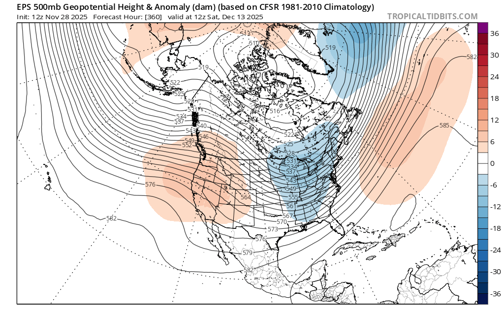
I’m not sold the EPS is correct in showing the split here with a cold Russia and cold North America….but it certainly fits current and the upcoming 10 days pattern overall.
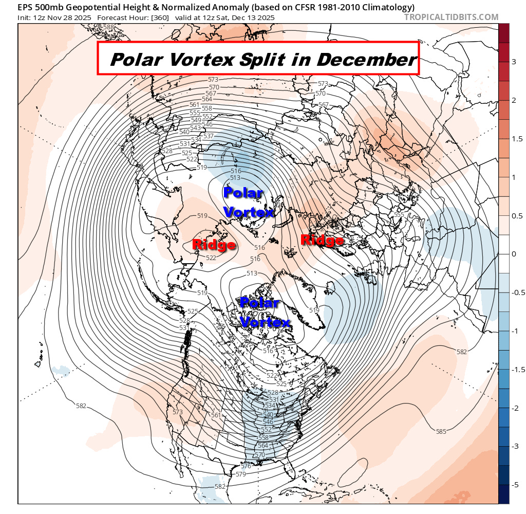
The Canadian and to some degree GFS also have this look

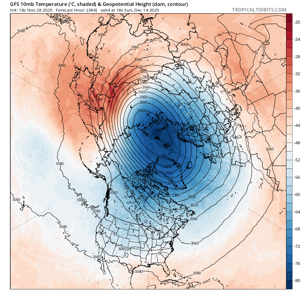
GFS December 14 forecast of a still-stretched out displaced stratospheric Polar Vortex. This is definitely a fluid situation and not set in stone. The more stretched and displaced probably means a cold Russia and atleast northern half of the USA (perhaps entire eastern half of the USA). The predictability of these SSW events is difficult and similar to Drought Forecasting. Drought feeds on drought and becomes a self-contained loop, feeding on itself, until something major disturbs it. The usual Polar Vortex doesn’t like to be disturbed and when it does, it’s chaotic to forecast and part of the feed back loop may play into this as well. One of Newton’s laws is that an object in motion stays in motion, or an object at rest remains at rest—unless acted upon by an outside force.
No matter how you slice it, some interesting times are coming to part of North America for a few weeks atleast. And for us in the South, colder and wetter will start to set in more so than we’ve seen all Autumn long. And for the Midwest to Northeast, already more snow is falling or soon will, compared to the entirety of Last Winter it seems. So that alone is telling. Action-Action-Action. Again though, I do believe we’ll see a nice warm up at some point in December. Just not sure when. By the same token, I think we repeat this exact same pattern later on.